I had so much fun using Google Earth! It’s an awesome app; I loved being able to “fly” around the world and to zoom in so far that individual houses could be seen (just as they can be when using the satellite feature on Google Maps). I did some “traveling” to my must-see locations, and then returned to my town in Pennsylvania, zooming in far enough to see my own house. It’s pretty neat.
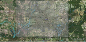
I chose to create a map of Berlin because I’ll be traveling there over winter break; I overlayed a map from the United Kingdom’s National Archives Education Division in its coverage of the Berlin Blockade/Cold War.
The overlay map shows the divisions of Berlin by France, the United Kingdom, the United States, and the Soviet Union after World War II, with this particular map referring specifically to the Berlin Blockade of 1948 – 1949. Berlin’s overall boundaries do not seem to have changed much from the mid-20th Century (black lines) to the present (purple lines), though differences are noticeable in the southwest corner and borders have changed slightly in the northwest corner. Even though there were relatively few major adjustments made to boundaries, matching the historic and present cities’ borders was still a little bit of a challenge and could not be completely accomplished. The hardest part of the exercise was finding a map of Berlin that I was able to use with the image overlay function; several would not show up–only a red ‘x’ would appear in their place. After finding this image, though, I was able to complete the exercise and became more comfortable with a variety of the layers on the Google Earth toolbar (for clarity’s sake, I didn’t use any of them in this first overlay).

